|
|
AIR POLLUTION IN THE CZECH REPUBLIC IN 2004 Czech Hydrometeorological Institute - Air Quality Protection Division |
|
|
|
|
PREFACE
Well-designed information support to facilitate decision-making processes is essential for the deployment of measures intended to improve the quality of the air in particular, and of the environment in general. In respect of air quality control regular, nation-wide assessment of air quality based on systematic monitoring and evaluation of air pollution data, precipitation quality data and emission data has become part of the standard service provided by the Czech Hydrometeorological Institute. An extensive set of tools for monitoring and objective assessment of air quality and its development in territory of the Czech Republic has been created, and is being constantly upgraded. In addition to assessments, studies, research reports and other documents prepared to meet specific purposes and requirements, it is the set of instruments for objective assessment, as developed and made available on a systematic basis, which constitutes the fundamental part of information support for the air quality control. One of the key components of this set of air quality monitoring and assessment tools is the Air Quality Information System (ISKO); one of the regular outputs of processing, on an annual basis, the data collected over the year in the ISKO database consists of the summary annual tabular survey Air Pollution and Atmospheric Deposition in Data, the Czech Republic (hereinafter the Tabular Survey), and this Yearbook, Air Pollution in the Czech Republic. These annual surveys are intended mainly for use by institutions and organisations concerned with the air and environment protection in this country. They are provided free-of-charge to state administration bodies concerned with air protection (the Ministry of the Environment of the Czech Republic, Regional Offices of the Ministry of the Environment, Environmental Departments of the regional authorities and of local authorities in basic administrative units with enlarged competencies, and the Czech Environmental Inspectorate, including its Regional Inspectorates), to all agencies that contribute to the ISKO database, including the Regional Public Health Services and Health Institutes, and to other selected entities. Every effort is made to improve and extend both the Tabular Survey and the Yearbook every year, with emphasis on information quality, data interpretation and formal aspects, based on our own knowledge and experience and the users’ comments. This Yearbook presents comprehensively in the form of tables, graphs and maps a summary overview of the status of air quality, including assessment of atmospheric deposition. While the Tabular Survey, which is published regularly before the Yearbook, provides an objective presentation of verified air pollution data and data on the chemical composition of atmospheric precipitation at individual localities, this Yearbook is focused mainly on map presentation showing the country’s territory loads caused by air pollution. In 2002 national legislation came into force covering comprehensively the field of ambient air protection and fully reflecting the European Union legislation. The basic documents are: the Act No. 86/2002 Coll. on clean air protection and amendment of some other acts (Clean Air Act) [7], in the wording of acts No. 521/2002 Coll., No. 92/2004 Coll., No. 186/2004 Coll., No. 695/2004 Coll. and No. 180/2005 Coll., and the Government Order No. 350/2002 Coll. setting forth limit values and procedures of monitoring, assessment, evaluation and management of air quality, in the wording of the Government Order No. 60/2004 Coll. [8]. The Yearbook reflects this fact by presenting the air quality assessment pursuant to this legislation starting from 2003. The assessment is carried out with regard to human health protection and the protection of ecosystems and vegetation respectively. This is the necessary prerequisite for the definition of areas with deteriorated air quality for which programmes aimed at the improvement of air quality or regulatory codes are required by the new legislation. In 2003 the national ambient air monitoring network was significantly changed in order to meet the requirements of the new legislation. The scope of the monitored pollutant increased, there were changes in the number of stations monitoring different pollutants, and several stations have been relocated. The reconstruction of the monitoring network was finished in 2004. The evaluation of spatial distribution of air pollution characteristics pursuant to the requirements of the Government Order No. 350/2002 Coll. is the basis for mapping and listing the areas with deteriorated air quality pursuant to Act No. 86/2002 Coll. Starting from 2004 the mapping of air quality characteristics on the territory of the Czech Republic uses 1x1 km grids. The maps are created on the basis of input data (i.e. measured values). In the localities where there is no measurement the model-based data or experts’ estimates are used. The maps are produced in cooperation with the specialists from CHMI branch offices who are acquainted with the detailed situation in the given region. The result maps of individual air quality characteristics are summed up into the maps of overall air quality assessment with regard to health protection and ecosystem and vegetation protection. On the basis of these summary maps the tables are produced and sent to the Ministry of the Environment as background materials for defining the areas with deteriorated air quality. In conclusion, it should be noted that this publication, and particularly the database on which it relies have only been made possible thanks to the efforts of numerous individuals, the staff of the Institute’s branches; of its Air Quality Protection Division’s laboratories; and of cooperating organisations. In addition to the data obtained from the Czech Hydrometeorological Institute’s own network and from the Health Institutes, the ISKO air pollution database receives and stores every year data from ÄŚEZ, a. s.; the Forest Management and Gamekeeping Research Institute; Czech Geological Survey (ÄŚGĂš); Water Management Research Institute (VĂšV); Ekotoxa Ltd. Opava, and from stations of municipal authorities. Since 1996, data for the German part of the Black Triangle provided by Landesamt für Umwelt und Geologie, Dresden, stored and presented in the ISKO air pollution database, have also been included both in the Tabular Survey and in this Yearbook. Since 1997 data for the Polish part provided by Wojewodski Inspektorat Ochrony Srodowiska in Jelenia Gora have been exchanged likewise. The responsibility for the collection and verification of data entered in the register of emissions from extra large and large pollution sources, REZZO 1, rests with the Czech Environmental Inspectorate. The collection and verification of data on emissions from medium-sized sources monitored within the REZZO 2, which represents a wide-scope activity, is the responsibility of the municipal authorities with extended competences. The data for inventories of emissions from mobile sources were processed by the experts from the Transport Research Centre (CDV) Brno. Basic topographic data were made available to the Czech Hydrometeorological Institute in a digitised form by the Military Topographic Institute in Dobruška. Important information was received from the Czech Statistical Office, Terplan, and other institutions. The Yearbook has been prepared and edited by a team of authors and editors of the Air Quality Protection Division of the Czech Hydrometeorological Institute, particularly from the Air Quality Information System Department, the Department of Emissions and Sources, the Department of Modelling and Expert’s Reports and the Department of Impact and Risk Assessment. Assistance and important technical support have been provided by IDEA-ENVI, Ltd.
Prague, August 2005
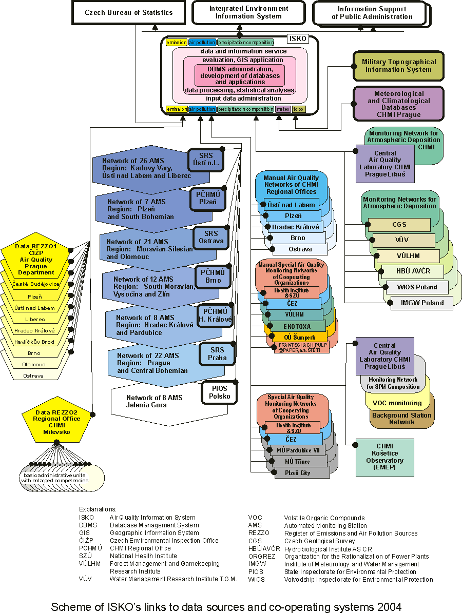
Database for Annual Processing and the Air Quality Information System This Yearbook is the result of annual data processing, especially of the systematically collected air pollution, emission and deposition data stored in the respective databases of the Air Quality Information System (ISKO). ISKO has been developed and operated since the beginning of 1992. The system is based on state-of-the-art information technologies and it represents an integrated system for nation-wide comprehensive assessment of the status and development of air quality. The system includes the collection, storage and processing of data from automatic and manually operated air pollution monitoring networks in the Czech Republic, and the storage and processing of data on emissions and air pollution sources. The Internal (later Air Pollution) Information System (IIS) has become an integral part of ISKO, as have other air quality databases, especially data entered in the register of emissions from large pollution sources (REZZO 1) and also the precipitation quality data. In 1993 the emission database was extended to include the outputs of medium-sized, individually monitored air pollution sources (REZZO 2). The Air Quality Information System collects and generally provides access to data gathered within major air pollution monitoring networks. It thus provides for a more effective and general utilisation of the expensive data. The integrated regionalised evaluation of air pollution levels, and analysis of the development over time of the status of air pollution in the Czech Republic would not be feasible without collecting and archiving systematically at one place all the air pollution data available. Moreover, the constant need to ensure that these assessments are objective requires simultaneous access to emission, meteorological and climate data, as well as geographical information on the location of pollution sources, the extent and sites of forests and residential areas, the routes of highways and railways, etc. When preparing charts and maps of the air pollution and deposition load on the country’s territory, geostatistical procedures and the tools of the Geographic Information System (GIS) map algebra are applied to estimate fields of air pollution and deposition characteristics derived from point (station) measurements. It is especially the method IDW (interpolation by a linearly weighted combination of a set of values measured around the interpolated point, where the weight is a function of inverse distance between the interpolated point and the point of measurement) and the interpolation method kriging (interpolation by a linearly weighted combination of a set of values measured around the interpolated point, where the weight is a function of a statistic structure of the air pollution, resp. the deposition field). Both of the above mentioned interpolation methods enable the performing of an objective analysis of the field, i.e. they allow value estimation in every point of the field. If the field is statistically homogeneous [1], the estimation by means of the kriging method is optimal in that sense, that it is unbiased and its mean square error is minimal. When the kriging method is applied, the program equipment of the Geographic Information System makes it possible to calculate errors of the estimation. Values of these errors show an efficiency of the enhancement of the density of the monitoring stations network and vice-versa. A number of the institutions mentioned earlier have been contributing to the air pollution database for many years. Information on the concentrations of sulphur dioxide and suspended particulate matter (SPM) obtained from the CHMI’s stations in northern Bohemia and in Prague, has been archived since 1971. In 2004, data was stored and processed from 267 localities in the Czech Republic, 8 stations in the Polish part of the Black Triangle. In accordance with the current legislation, the Czech Environmental Inspectorate and the authorities of basic administrative units with extended scope of competences ensure the verification of data from operational summaries. The operational summaries constitute the basic source of information for processing the REZZO 1 and REZZO 2 databases. Methodical development and technical provision for annual nation-wide procession and keeping of records of the REZZO 1 and REZZO 2databases are carried out by CHMI. In the framework of the emission coverage of ISKO the annual overviews of emission data and supplementary technical information have been filed since 1993, from large sources and technical provision has been made for data service including preprinted forms of operation records. Within the REZZO 2database files are kept of emission and supplementary technical data from more than 30,000 medium-sized sources, including data service. Emissions from small sources (household heating units) are inventoried according to the 1997 methodology of data processing based on the 1991 and 2001 General Census. Its output includes information on the consumption of principal fuels in households. The data are regularly (once a year) updated in cooperation with regional fuels and energy suppliers. The final output of the REZZO 3 database consists in data on emission of pollutants and on fuel composition for household heating units at local level. The total balance of small sources does not include data on emission from small plants for which payments are made to the local and municipal authorities. Data on emissions from REZZO 4 sources cover road, railway, water and air transport based on processing by the Transport Research Centre (CDV) in Brno. Since 1996 the REZZO 4 database has included also data on emissions from agricultural and forest machinery processed by the Research Institute of Agricultural Technology (VĂšZT) in Prague. On the basis of information on total consumption of fuels calculations have been made of emissions from further mobile sources (building machines, in-plant transport and army vehicles) since 1997. The creation of the basic geographic and topical layers in standardised projection (conform Gauss-Krüger projection) was launched in 1994. The DMĂš 200 and DMR-2digital layers are used to form the basic layers of the GIS: orography, the most important watercourses, water areas, settlements, administrative borders of Districts, highway networks, and the vegetation cover. Fig. -1 schematically depicts ISKO’s links to data sources and co-operating systems. The scheme outlines the interconnection of air quality monitoring networks and sources of data on air emission with data processing and information layers represented by ISKO, and the linkage to a higher-level layer – “cross-sectional” information systems. The actual interconnection is carried out through exchange of data by e-mail, on magnetic media, over switched data lines and, in case of data from the automated air pollution monitoring (AIM) network, mainly over radio transmission. Since 1993, both the Tabular Survey and the Yearbook have been completely produced with the help of a computer system based on an innovated concept. It consists of a computer network around a database server with the multi-user relational database system installed and working under the Unix operating system. The new data model ISKO2project was implemented in 2003 under RSBMS Oracle. ISKO2 meets the growing demands on data presentation in various forms incl. internet publication. The concept of the system is based on distributed processing in local networks on Sun workstations and PCs, with direct access of processing and analytical programs – such as the Geographic Information System (ARC/INFO) on Sun Blade 1000, statistical programs (SPSS, Systat), spreadsheet and graphic programs – to the data stored in the central database which features uninterrupted and backed-up operation. The Czech Hydrometeorological Institute has its regional offices in all the former regional capitals; these are mainly concerned with measurements, and data collection and data initial processing within their respective regions. The offices are connected to the central system in Prague via CHMI’s private WAN data network operating with TCP/IP protocol. The selected information, tables, graphs and maps on air quality published in the Tabular Survey and in the Yearbook are accessible in the Internet. Fig. –1 Scheme of ISKO’s links to data sources and co-operating systems
|