Information about air quality in the Czech Republic
Current overview of data from automated stations (non-verified data)
Updated: 2024-05-08 16:29 CEST
Locality
| Locality: |
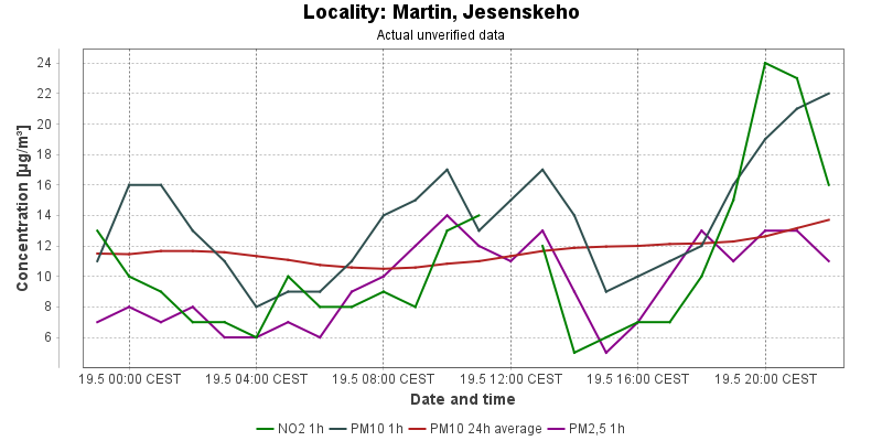
Martin, Jesenskeho
|
| Code: |
8MAJA |
| Type of measuring programme: |
Automated measuring program |
| Locality owner: |
Slovak Hydrometeorological Institute |
| Abbreviation: |
T/U/- |
| Coordinates: |
49° 4´ 0.999" North latitude 18° 55´ 18.997" East longitude |
| Altitude: |
383 m |
Actual measured level of air pollution
Actual unverified data
| 2024-05-07 16:00 - 17:00 CEST |
|
|
11.0 |
509.5 |
|
|
16.0 |
12.2 |
10.0 |
| 2024-05-07 17:00 - 18:00 CEST |
|
|
15.0 |
493.6 |
|
|
16.0 |
12.6 |
11.0 |
| 2024-05-07 18:00 - 19:00 CEST |
|
|
17.0 |
477.9 |
|
|
17.0 |
12.9 |
14.0 |
| 2024-05-07 19:00 - 20:00 CEST |
|
|
16.0 |
461.5 |
|
|
16.0 |
13.0 |
13.0 |
| 2024-05-07 20:00 - 21:00 CEST |
|
|
20.0 |
453.6 |
|
|
18.0 |
13.2 |
12.0 |
| 2024-05-07 21:00 - 22:00 CEST |
|
|
12.0 |
448.9 |
|
|
15.0 |
13.2 |
11.0 |
| 2024-05-07 22:00 - 23:00 CEST |
|
|
7.0 |
445.4 |
|
|
15.0 |
13.4 |
13.0 |
| 2024-05-07 23:00 - 00:00 CEST |
|
|
7.0 |
448.2 |
|
|
12.0 |
13.3 |
9.0 |
| 2024-05-08 00:00 - 01:00 CEST |
|
|
4.0 |
446.6 |
|
|
11.0 |
13.2 |
10.0 |
| 2024-05-08 01:00 - 02:00 CEST |
|
|
4.0 |
444.5 |
|
|
9.0 |
12.9 |
9.0 |
| 2024-05-08 02:00 - 03:00 CEST |
|
|
4.0 |
440.8 |
|
|
11.0 |
12.6 |
11.0 |
| 2024-05-08 03:00 - 04:00 CEST |
|
|
3.0 |
438.6 |
|
|
12.0 |
12.4 |
9.0 |
| 2024-05-08 04:00 - 05:00 CEST |
|
|
4.0 |
437.8 |
|
|
11.0 |
12.4 |
9.0 |
| 2024-05-08 05:00 - 06:00 CEST |
|
|
5.0 |
434.9 |
|
|
11.0 |
12.5 |
10.0 |
| 2024-05-08 06:00 - 07:00 CEST |
|
|
6.0 |
434.6 |
|
|
9.0 |
12.4 |
9.0 |
| 2024-05-08 07:00 - 08:00 CEST |
|
|
6.0 |
429.8 |
|
|
10.0 |
12.5 |
9.0 |
| 2024-05-08 08:00 - 09:00 CEST |
|
|
6.0 |
429.3 |
|
|
9.0 |
12.3 |
7.0 |
| 2024-05-08 09:00 - 10:00 CEST |
|
|
5.0 |
432.1 |
|
|
8.0 |
12.2 |
10.0 |
| 2024-05-08 10:00 - 11:00 CEST |
|
|
5.0 |
434.3 |
|
|
7.0 |
12.1 |
10.0 |
| 2024-05-08 11:00 - 12:00 CEST |
|
|
5.0 |
435.4 |
|
|
7.0 |
11.9 |
9.0 |
| 2024-05-08 12:00 - 13:00 CEST |
|
|
6.0 |
436.9 |
|
|
9.0 |
11.8 |
7.0 |
| 2024-05-08 13:00 - 14:00 CEST |
|
|
5.0 |
434.4 |
|
|
9.0 |
11.8 |
10.0 |
| 2024-05-08 14:00 - 15:00 CEST |
|
|
5.0 |
434.9 |
|
|
8.0 |
11.6 |
10.0 |
| 2024-05-08 15:00 - 16:00 CEST |
|
|
5.0 |
435.9 |
|
|
10.0 |
11.5 |
9.0 |
|
|
Component is not measured |
|
|
Incomplete data |
|
|
Limit exceeded |
Map of station position
Map is on page with detailed information about locality
 ISKO
ISKO