Information about air quality in the Czech Republic
Current overview of data from automated stations (non-verified data)
Updated: 2024-05-08 23:30 CEST
Locality
| Locality: |
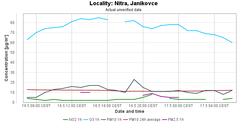
Nitra, Janikovce
|
| Code: |
4NIJA |
| Type of measuring programme: |
Automated measuring program |
| Locality owner: |
Slovak Hydrometeorological Institute |
| Abbreviation: |
B/U/- |
| Coordinates: |
48° 17´ 0.000" North latitude 18° 8´ 0.000" East longitude |
| Altitude: |
135 m |
Actual measured level of air pollution
Actual unverified data
| 2024-05-07 23:00 - 00:00 CEST |
|
|
4.0 |
|
42.0 |
48.8 |
5.0 |
8.2 |
5.0 |
| 2024-05-08 00:00 - 01:00 CEST |
|
|
4.0 |
|
41.0 |
48.4 |
4.0 |
8.0 |
|
| 2024-05-08 01:00 - 02:00 CEST |
|
|
3.0 |
|
|
48.1 |
9.0 |
7.8 |
|
| 2024-05-08 02:00 - 03:00 CEST |
|
|
4.0 |
|
38.0 |
45.3 |
8.0 |
7.8 |
|
| 2024-05-08 03:00 - 04:00 CEST |
|
|
5.0 |
|
39.0 |
42.7 |
7.0 |
7.5 |
|
| 2024-05-08 04:00 - 05:00 CEST |
|
|
5.0 |
|
37.0 |
41.6 |
10.0 |
7.5 |
|
| 2024-05-08 05:00 - 06:00 CEST |
|
|
5.0 |
|
39.0 |
40.3 |
11.0 |
7.8 |
|
| 2024-05-08 06:00 - 07:00 CEST |
|
|
4.0 |
|
41.0 |
39.6 |
11.0 |
8.2 |
|
| 2024-05-08 07:00 - 08:00 CEST |
|
|
5.0 |
|
39.0 |
39.1 |
11.0 |
8.5 |
|
| 2024-05-08 08:00 - 09:00 CEST |
|
|
4.0 |
|
36.0 |
38.4 |
8.0 |
8.8 |
4.0 |
| 2024-05-08 09:00 - 10:00 CEST |
|
|
3.0 |
|
51.0 |
40.0 |
10.0 |
9.1 |
6.0 |
| 2024-05-08 10:00 - 11:00 CEST |
|
|
4.0 |
|
51.0 |
41.6 |
9.0 |
9.1 |
|
| 2024-05-08 11:00 - 12:00 CEST |
|
|
6.0 |
|
44.0 |
42.2 |
14.0 |
9.2 |
|
| 2024-05-08 12:00 - 13:00 CEST |
|
|
|
|
51.0 |
44.0 |
20.0 |
9.8 |
|
| 2024-05-08 13:00 - 14:00 CEST |
|
|
3.0 |
|
64.0 |
47.1 |
8.0 |
9.8 |
|
| 2024-05-08 14:00 - 15:00 CEST |
|
|
3.0 |
|
67.0 |
50.4 |
11.0 |
9.9 |
|
| 2024-05-08 15:00 - 16:00 CEST |
|
|
3.0 |
|
62.0 |
53.2 |
18.0 |
10.1 |
|
| 2024-05-08 16:00 - 17:00 CEST |
|
|
3.0 |
|
64.0 |
56.8 |
17.0 |
10.2 |
|
| 2024-05-08 17:00 - 18:00 CEST |
|
|
4.0 |
|
75.0 |
59.8 |
13.0 |
10.2 |
|
| 2024-05-08 18:00 - 19:00 CEST |
|
|
4.0 |
|
76.0 |
62.9 |
13.0 |
10.4 |
|
| 2024-05-08 19:00 - 20:00 CEST |
|
|
5.0 |
|
75.0 |
66.8 |
15.0 |
10.8 |
|
| 2024-05-08 20:00 - 21:00 CEST |
|
|
6.0 |
|
69.0 |
69.0 |
15.0 |
11.0 |
|
| 2024-05-08 21:00 - 22:00 CEST |
|
|
6.0 |
|
61.0 |
68.6 |
12.0 |
11.1 |
|
| 2024-05-08 22:00 - 23:00 CEST |
|
|
10.0 |
|
48.0 |
66.2 |
12.0 |
11.3 |
|
|
|
Component is not measured |
|
|
Incomplete data |
|
|
Limit exceeded |
Map of station position
Map is on page with detailed information about locality
 ISKO
ISKO