Information about air quality in the Czech Republic
Current overview of data from automated stations (non-verified data)
Updated: 2024-04-26 10:29 CEST
Locality
| Locality: |
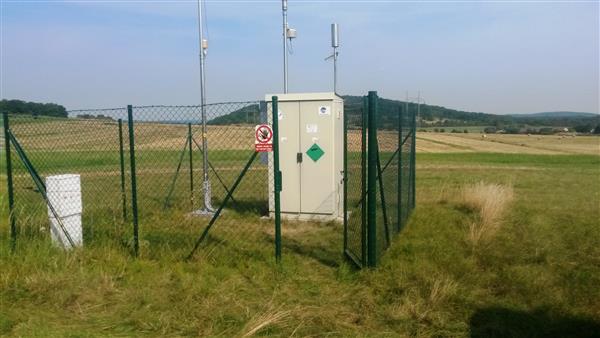
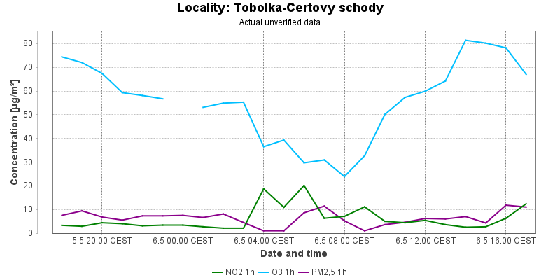
Tobolka-Certovy schody
|
|
| Code: |
STCSA |
| Type of measuring programme: |
Automated measuring program |
| Locality owner: |
Vapenka Certovy schody, a.s. |
| Abbreviation: |
B/R/AN-NCI |
| Coordinates: |
49° 55´ 6.610" North latitude 14° 5´ 40.161" East longitude |
| Altitude: |
420 m |
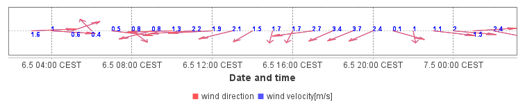
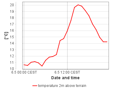
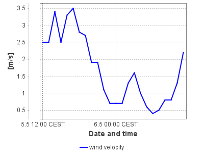
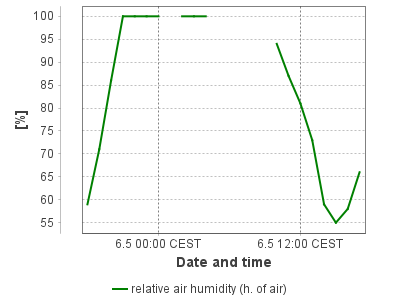
Actual measured level of air pollution
Actual unverified data
| 2024-04-25 10:00 - 11:00 CEST |
|
|
4.0 |
196.1 |
77.0 |
73.3 |
|
|
4.6 |
| 2024-04-25 11:00 - 12:00 CEST |
|
|
4.0 |
179.9 |
76.6 |
74.1 |
|
|
12.3 |
| 2024-04-25 12:00 - 13:00 CEST |
|
|
4.0 |
182.7 |
83.2 |
75.3 |
|
|
21.2 |
| 2024-04-25 13:00 - 14:00 CEST |
|
|
3.4 |
185.1 |
90.8 |
77.8 |
|
|
1.0 |
| 2024-04-25 14:00 - 15:00 CEST |
|
|
|
190.6 |
91.4 |
80.3 |
|
|
3.2 |
| 2024-04-25 15:00 - 16:00 CEST |
|
|
2.9 |
193.6 |
95.6 |
83.0 |
|
|
3.1 |
| 2024-04-25 16:00 - 17:00 CEST |
|
|
2.7 |
|
94.0 |
85.5 |
|
|
2.8 |
| 2024-04-25 17:00 - 18:00 CEST |
|
|
3.3 |
|
98.4 |
88.4 |
|
|
1.0 |
| 2024-04-25 18:00 - 19:00 CEST |
|
|
5.2 |
|
91.8 |
90.2 |
|
|
4.1 |
| 2024-04-25 19:00 - 20:00 CEST |
|
|
3.3 |
|
86.8 |
91.5 |
|
|
5.9 |
| 2024-04-25 20:00 - 21:00 CEST |
|
|
2.9 |
|
83.2 |
91.5 |
|
|
4.6 |
| 2024-04-25 21:00 - 22:00 CEST |
|
|
3.4 |
|
81.2 |
90.3 |
|
|
6.3 |
| 2024-04-25 22:00 - 23:00 CEST |
|
|
5.2 |
181.4 |
75.0 |
88.2 |
|
|
6.9 |
| 2024-04-25 23:00 - 00:00 CEST |
|
|
3.1 |
179.2 |
78.6 |
86.1 |
|
|
9.4 |
| 2024-04-26 00:00 - 01:00 CEST |
|
|
2.3 |
175.5 |
|
85.0 |
|
|
6.5 |
| 2024-04-26 01:00 - 02:00 CEST |
|
|
2.1 |
172.4 |
72.0 |
81.2 |
|
|
5.2 |
| 2024-04-26 02:00 - 03:00 CEST |
|
|
2.3 |
172.5 |
71.8 |
78.4 |
|
|
4.0 |
| 2024-04-26 03:00 - 04:00 CEST |
|
|
2.3 |
173.5 |
67.6 |
75.6 |
|
|
5.5 |
| 2024-04-26 04:00 - 05:00 CEST |
|
|
2.3 |
174.6 |
69.2 |
73.6 |
|
|
7.2 |
| 2024-04-26 05:00 - 06:00 CEST |
|
|
2.3 |
163.0 |
72.4 |
72.4 |
|
|
6.0 |
| 2024-04-26 06:00 - 07:00 CEST |
|
|
6.5 |
153.7 |
45.9 |
68.2 |
|
|
7.1 |
| 2024-04-26 07:00 - 08:00 CEST |
|
|
4.4 |
150.4 |
57.7 |
65.2 |
|
|
8.5 |
| 2024-04-26 08:00 - 09:00 CEST |
|
|
6.7 |
152.9 |
67.8 |
65.6 |
|
|
7.5 |
| 2024-04-26 09:00 - 10:00 CEST |
|
|
4.0 |
153.8 |
81.8 |
66.8 |
|
|
5.8 |
|
|
Component is not measured |
|
|
Incomplete data |
|
|
Limit exceeded |
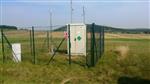
Map of station position
Map is on page with detailed information about locality
 ISKO
ISKO