Information about air quality in the Czech Republic
Current overview of data from automated stations (non-verified data)
Updated: 2024-04-17 01:30 CEST
Locality
| Locality: |
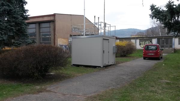
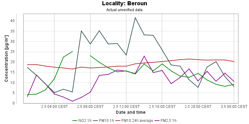
Beroun
|
|
| Code: |
SBERA |
| Type of measuring programme: |
Automated measuring program |
| Locality owner: |
Czech Hydrometeorological Institute |
| Abbreviation: |
T/U/RCI |
| Coordinates: |
49° 57´ 28.540" North latitude 14° 3´ 29.880" East longitude |
| Altitude: |
216 m |
Actual measured level of air pollution
Actual unverified data
| 2024-04-16 01:00 - 02:00 CEST |
|
|
1.0 |
340.3 |
|
|
5.0 |
11.4 |
10.4 |
| 2024-04-16 02:00 - 03:00 CEST |
|
|
1.0 |
337.0 |
|
|
5.1 |
11.1 |
7.8 |
| 2024-04-16 03:00 - 04:00 CEST |
|
|
2.1 |
336.4 |
|
|
4.7 |
10.6 |
4.6 |
| 2024-04-16 04:00 - 05:00 CEST |
|
|
6.1 |
333.1 |
|
|
3.7 |
10.2 |
3.8 |
| 2024-04-16 05:00 - 06:00 CEST |
|
|
7.7 |
330.7 |
|
|
2.1 |
10.0 |
2.8 |
| 2024-04-16 06:00 - 07:00 CEST |
|
|
20.7 |
331.4 |
|
|
2.1 |
9.5 |
1.0 |
| 2024-04-16 07:00 - 08:00 CEST |
|
|
18.2 |
337.7 |
|
|
5.9 |
8.9 |
1.0 |
| 2024-04-16 08:00 - 09:00 CEST |
|
|
17.0 |
339.0 |
|
|
4.5 |
8.6 |
1.0 |
| 2024-04-16 09:00 - 10:00 CEST |
|
|
12.8 |
338.1 |
|
|
20.5 |
8.7 |
1.0 |
| 2024-04-16 10:00 - 11:00 CEST |
|
|
4.0 |
337.9 |
|
|
18.3 |
8.6 |
6.6 |
| 2024-04-16 11:00 - 12:00 CEST |
|
|
4.2 |
336.1 |
|
|
15.4 |
8.8 |
4.8 |
| 2024-04-16 12:00 - 13:00 CEST |
|
|
5.4 |
335.5 |
|
|
10.6 |
8.7 |
8.1 |
| 2024-04-16 13:00 - 14:00 CEST |
|
|
3.6 |
332.9 |
|
|
17.3 |
9.0 |
16.3 |
| 2024-04-16 14:00 - 15:00 CEST |
|
|
9.9 |
331.9 |
|
|
11.6 |
8.5 |
11.6 |
| 2024-04-16 15:00 - 16:00 CEST |
|
|
11.9 |
328.6 |
|
|
11.5 |
8.3 |
5.6 |
| 2024-04-16 16:00 - 17:00 CEST |
|
|
14.9 |
327.4 |
|
|
7.9 |
8.2 |
3.2 |
| 2024-04-16 17:00 - 18:00 CEST |
|
|
10.9 |
328.6 |
|
|
4.7 |
8.1 |
2.5 |
| 2024-04-16 18:00 - 19:00 CEST |
|
|
18.0 |
331.6 |
|
|
4.1 |
7.7 |
2.0 |
| 2024-04-16 19:00 - 20:00 CEST |
|
|
19.9 |
335.2 |
|
|
3.3 |
7.4 |
1.0 |
| 2024-04-16 20:00 - 21:00 CEST |
|
|
12.1 |
337.1 |
|
|
4.0 |
7.3 |
2.0 |
| 2024-04-16 21:00 - 22:00 CEST |
|
|
15.7 |
341.2 |
|
|
3.9 |
7.2 |
1.0 |
| 2024-04-16 22:00 - 23:00 CEST |
|
|
8.4 |
341.9 |
|
|
3.3 |
7.2 |
1.0 |
| 2024-04-16 23:00 - 00:00 CEST |
|
|
|
343.7 |
|
|
4.1 |
7.3 |
1.0 |
| 2024-04-17 00:00 - 01:00 CEST |
|
|
4.8 |
342.4 |
|
|
3.3 |
7.4 |
1.0 |
|
|
Component is not measured |
|
|
Incomplete data |
|
|
Limit exceeded |
Map of station position
Map is on page with detailed information about locality
 ISKO
ISKO