II. AMBIENT AIR POLLUTION
LEVELS IN THE CZECH REPUBLIC
II.1 Networks of Ambient Air Quality
Monitoring Stations
The ambient air pollution situation has been assessed based on the data archived
in the ISKO air pollution database. In addition to the data from CHMI networks,
several other organisations that play an important role in air pollution
monitoring in the Czech Republic have also been contributing to the ISKO
database for a number of years. As it was stated in the Preface, since 1996, the
data for the German part of the Black Triangle has been included and presented
in the air pollution ISKO database, and the data for the Polish border area has
been included since 1997 likewise.
In early 2000 there emerged the need to optimize the air pollution network in
order to provide the state bodies with the necessary information for the whole
Czech Republic territory and the tools for fulfilling the tasks set by the
respective EU directives and by the obligations ensuing from international
agreements adopted by the Czech Republic in the field of air quality protection
and to site the monitoring stations pursuant to the requirements of EU
directives. Simultaneously the urgent need emerged to innovate the instruments
worn down by continuous operation which resulted in ever increasing failure rate.
Within the R&D project the Draft of the optimalized network of air quality
monitoring was presented followed up in 2002 by the Implementation project of
the National air pollution network (SIS) including the AIM network and the
supplementary network with manual sampling. The SIS project, pursuant to §6,
Art. 8 and §7, Art.. 5 of the Clean Air Act No. 86/2002 Coll., aimed at ambient
air quality monitoring in the whole territory of the Czech Republic, and namely
in the areas with deteriorated air quality. The project also considered new
knowledge and requirements concerning the monitored pollutants, as well as the
change in the emission situation in the Czech Republic. Pollutants’ monitoring
within the national air pollution network was aimed mainly at the pollutants
with the set limit values. It was supposed that the proposed SIS, operated by
one authorized organization, is the basic component of air quality monitoring in
the Czech Republic. If necessary it can be combined with and use the data from
the specialized networks of other organizations or the monitoring stations
operated at a lower level (regions and selected basic administrative units).
This network, established with the PHARE project contribution, was launched on 1
January 2004.
Tables II.1.1–II.1.5 present the oveviews of the numbers of localities in the
respective zones and agglomerations from which the measured data were supplied
to the Air Quality Information System (ISKO) database.
Table II.1.1 provides the overview of the number of localities, broken down by
the owners operating the respective monitoring network. Usually only one
measuring programme is installed per the respective locality. Several localities,
particularly the CHMI ones, operate more than one measuring programme, for
example the stations Prague 4-Libuš, Košetice, ĂšstĂ n. L.-KoÄŤkov, BĂlĂ˝ KĹ™ĂĹľ and
some others at which automatic, manual and semiautomatic measuring programmes
have been installed, as also those intended for the monitoring of PAHs and heavy
metals.
Table II.1.2 lists the number of air pollution monitoring localities at which
basic pollutants are monitored automatically. At AIM stations the pollutants are
measured by continual analysers and the measured concentrations are as 1 hour
averages transmitted in real time via switched lines or via radio transmission
for further processing.
Table II.1.3 shows the number of localities in individual regions at which
further pollutants, incl. supplementary meteorological parameters are monitored
automatically.
Table II.1.4 lists the number of localities in individual regions at which the
listed pollutants are monitored by manual methods.
Table II.1.5 presents the total numbers of localities in individual regions with
special measurements using manual methods.
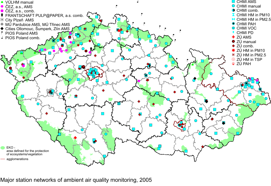
Network density in each of the Czech Republic’s regions and monitoring
organisations’ involvement are illustrated in Fig. II.1.1.
The graphs in Fig. II.1.2 illustrate how the measurement of principal air
pollutants has developed since 1971 for the organisations and network types
listed; the measured data are archived in the ISKO database.
The production of maps of air pollution characteristics presented in this
Yearbook is guided by the classification of the measuring stations carried out
within the research project VaV740/2/00 “Evaluation of the Czech Republic
Readiness to Meet Air Quality Requirements of EU Directives and the LRTAP
Convention” [3] and further developed.
This classification is based on the Council Decision 97/101/EC on exchange of
information (EoI) [4] and Criteria for EUROAIRNET [5]. The requirements of the
Council Decision 97/101/EC are obligatory for the EU Member States.
Due to the fact that this is the only official European classification it has
been applied to all air pollution stations in the Czech Republic registered in
the ISKO database.
The classification of the SIS monitoring stations in the Czech Republic is
described in Sládeček, J., Blažek, Z. (2000): Application of criteria for the
classification of stations and station networks pursuant to the EoI Decision
97/101/EC and Criteria for EUROAIRNET to the stations included in the air
quality assessment process. The Report on the task DU01-1.E1 of the R&D Project
VaV/740/2/00, CHMI, Prague.
The EoI classification was simplified by the Decision of the European Commission
2001/752/EC. The character of the location of some monitoring stations in the
Czech Republic, however, corresponds rather with the classification in the
original version of 1997 and thus it continues to be used in the ISKO database.
The Yearbook uses the term “type of area” instead of “type of zone” in
accordance with the Council Decision 2001/752/EC.
The complete EoI classification (Table II.1.6) consisting of 3 fundamental
letters divided by strokes is presented only in those stations at which it was
officially affirmed by an expert team in accordance with local criteria. In some
cases incomplete classification is presented (1–2 letters only) derived from the
purpose of the station establishment.
The third column of the table II.1.6 shows only the examples of the combinations
of zone characterisation. Any logical combination is possible and the order of
letters in the abbreviation is meaningful – the first position is always of the
highest priority.
The legends in maps of fields of pollutants concentrations the EoI
classification is used in a simplified form based mainly on the type of area
according to the Decision 2001/752/EC. The correct application of this
classification during the production of maps of fields of pollutants is bound to
the recommended area of representativeness (radius of area) for the various
station types:
- traffic – station directly influenced by traffic, located within 50 m
from the communication with high traffic intensity; the station should cover
the longest part of the road/street, the area of representativeness is not
applicable here appropriately (mentioned in the Criteria for EUROAIRNET
(Draft 98) less than 10–15 m). The area of representativeness can be defined
in terms of length of road: city centre more than 100 m, suburban areas more
than 1000 m.
- industrial – station directly influenced by industry, located on the
premises of a factory or at sites of potential influence of the smoke plume
from the sources in the prevailing wind direction. The area of
representativeness of the station is 10–100 m.
- background – station in unafflicted localities, measuring the background
of regions, cities and industrial areas. The station should not be directly
afflicted by any source. The area of representativeness of the station
differs as follows:
- in urban and suburban stations more than 1–1.5 km,
- in rural stations from more than 5 to cca 60 km (in the Czech Republic
usually between 10 and 20 km).
In 2005 three specialized stations marked as traffic hot spot were in
operation, and namely Prague 2-Legerova, Ústà n.L.-Všebořická and
Ostrava-Českobratrská. These measuring sites are exclusively traffic oriented
and their air pollution loads result from this. These stations meet the criteria
for traffic-oriented samplers pursuant to the Government Order No. 350/2002 Coll.
(For the measuring of all pollutants at least 25 meters from the edge of big
crossroads and at least 4 meters from the centre of the nearest traffic lane.)
More detailed overview of background rural stations into subcategories pursuant
to the Decision 2001/752/EC and Criteria for EUROAIRNET, Technical Report no.
12, EEA have been presented in the tables since 2004.
- near-city, code NCI, located in rural/agricultural areas, with a distance of
3–10 km from built-up areas and other major sources, radius larger than about 5
km.
- regional, code REG, located in rural/agricultural areas, with a distance of
10–50 km from built-up areas and other major sources, radius larger than about
20 km.
- remote, code REM, located in rural/natural areas, with a minimum distance of
50 km to built-up areas and other major sources, radius larger than about 60 km.
Further details on station networks, the measurement methods used, on the
detection limits of different methods used, and the detailed updated list of
stations broken by territorial units and further specific data can be found in
the summary Tabular Survey [2].
The degree of usability of the data supplied by the institutions that
contributed to the ISKO database in the year under review (i.e. data capture) is
listed in Tables II.1.7–II.1.10. For the parameters assessed these tables
compare the number of those monitoring stations in the networks reviewed, which
meet the criteria for the validity of annual air pollution characteristics (see
the numerator), and the total number of stations of the given network measuring
the respective parameter (see the denominator). This proportion of valid data
from the annual file of the measured and verified data, submitted for the given
parameter by the respective organization/network, is expressed as percentage (see
the number below the fraction). Data validity is based on the longest-lasting
continuous measurement failure in a year (NSV) and the minimum required
percentage (MP) of valid data within the annual data file. Being the basic
parameters of the criterion of comprehensiveness and uniformity of the data
entered into the annual air pollution characteristics computations, the longest-lasting
continuous failure in a year – expressed as a certain number of days – and the
required minimum percentage of valid data are evaluated during the annual data
processing, and stored as part of the annual data file for each station and for
each parameter.
The criterion of the minimum percentage of valid data MP≥66 % and the longest-lasting
continuous failure NSV≤40 is used for setting the valid annual arithmetic
average of concentrations of the given substance as well as for the data capture
(see Tables II.1.7–II.1.10). During 2003 and 2004 the CHMI measuring network
changed significantly. The measuring sites were located with regard to the
monitoring aims set in the respective EU directives, the Clean Air Act No.
86/2002 Coll. and the Government Order No. 350/2002 Coll. The changes were
finished in 2004 and the measuring programmes and types of pollutants’
measurement ensure the ambient air quality monitoring in the whole territory of
the Czech Republic and mainly in the areas with deteriorated air quality.
Tab. II.1.1 Air pollution monitoring localities,
based on the owner, Czech Republic, 2005
Tab. II.1.2 Air pollution monitoring localities measuring basic pollutants, AMS,
based on the owner, Czech Republic, 2005
Tab. II.1.3 Air pollution monitoring localities measuring other pollutants and
supplementary quantities, AMS, based on the owner, Czech Republic, 2005
Tab. II.1.4 Air pollution monitoring localities
measuring basic pollutants, manual methods, based on the owner, Czech Republic,
2005
Tab. II.1.5 Total number of
monitoring localities with special measurements, manual methods, based on the
owner, Czech Republic, 2005
Tab. II.1.6
Exchange of Information (EoI) station classification
Tab. II.1.7 Percentage of valid data from the stations
with continuous measurement, 2005
Tab.
II.1.8 Percentage of valid data from the stations with manual measurement, 2005
Tab. II.1.9 Percentage of valid data from the
stations measuring meteorological parameters, 2005
Tab. II.1.10 Percentage of data from other
measurements, 2005

Fig. II.1.1 Major station networks of ambient air quality monitoring, 2005
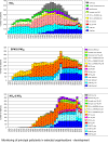
Fig. II.1.2 Monitoring of principal pollutants in selected organisations –
development